Upper Dolpo Trek
Trip Overview
Unveiling the Hidden Beauty: Upper Dolpo Trek
Discover the untouched allure of Nepal through the enigmatic Upper Dolpo trek. It’s a haven for adventurers seeking serenity amidst nature’s grandeur. Situated in the remote reaches of northwestern Nepal, Upper Dolpo boasts a rugged landscape waiting to be explored.
Into the Wilderness: Exploring Upper Dolpo
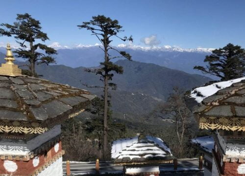
Embark on a journey through towering pine and cedar forests. Marvel at vistas of the majestic Dhaulagiri mountain painting the horizon. Traverse the Jangla Bhanjyang Pass at 4500 meters, where a gateway to Dolpo unveils itself. Witness snow-capped peaks adorning the valley’s head, leading to the expansive Tibetan plateau beyond.
Survival Amidst Adversity: The Dolpo People
In this arid realm shielded from rain, the resilient Dolpo people have forged a life through trade with neighboring Tibet. They’ve overcome nature’s challenges with resourcefulness. Their enduring spirit adds a rich layer to the trekking experience, offering insight into a way of life shaped by harsh landscapes and ancient traditions.
Phoksundo (Ringmo): A Vision of Beauty
Experience the ethereal beauty of Phoksundo (Ringmo), home to the revered monastery of the pre-Buddhist Bonpo sect. Behold its breathtaking landscapes, a testament to nature’s artistry. The tranquil turquoise waters of Phoksundo Lake, set against a backdrop of rugged peaks, create a scene of unparalleled serenity.
A Trek for the Brave
Embark on this odyssey reserved for the bold and adventurous. Upper Dolpo stands as Nepal’s least populated and most isolated region, offering an unparalleled journey into the heart of wilderness. This trek is not merely a physical challenge but a spiritual awakening. Each step reveals the hidden treasures of Nepal’s natural and cultural heritage. Whether traversing rugged terrain or immersing in the tranquility of remote villages, the Upper Dolpo trek promises an unforgettable adventure for those willing to venture off the beaten path.
Trip Itinerary
A representative of Adventure Glacier Treks will meet you at the arrival gate of Tribhuvan International Airport (TIA), Kathmandu. And you will be transferred to a hotel, after which there will be a briefing about the necessary procedures, the climbing route, and your climbing permit. Depending on your arrival time, you can spend your free time visiting nearby temples or taking a break.
We will analyze the gear you need for the treks and, if we have any, recommend that you buy, rent, or receive it from us. The Kathmandu Valley may be explored in a single day. If you'd like, we may arrange for a tour guide to assist you as you tour Kathmandu (it costs extra).
From Kathmandu, we fly for an hour to Nepalgunj in the country's west. The entry point to Simikot of Humla is Nepalgunj, a border town close to the Nepal-India border. The town itself is a fascinating Terai town in Nepal, influenced by the indigenous Hindu and Muslim traditions as well as the country's hills and plains. The Mini Zoo and Muslim Bazaar are two tourist attractions in Nepalgunj. If time permits and you're interested, you may also go for a walk around some of the local villages. Additionally, we need to get ready for our trip tomorrow.
We take a flight to Juphal, which takes around 35 minutes, from Nepalgunj. The Twin Otter serves as the main form of transportation between Juphal and Nepalgunj as well as between Juphal and Nepalgunj runways. This service is essentially reliable. Flights may occasionally be postponed because of bad weather or other technical issues. After arriving in Juphal, we'll meet the trekking team, pack our gear, and proceed to walk through terraced fields to the Bheri River and the confined canyon. After three hours of walking, you'll arrive in the somewhat larger village of Dunai. Spend the night in a tent camp.
Following the trail past the new hospital, you cross the new suspension bridge from Dunai and turn west. You turn north and follow the Suli Gad after the Thuri Bheri and Suli Gad rivers meet. The travel is smooth despite the trail's moderate fluctuations, which are largely upward. The river is constantly nearby, and you can always hear its roar. You pass through an area that is covered with marijuana plants but also has millet, pumpkin, potatoes, sweet corn, and chilies for the residents and animals. A large number of the communities in this region are engaged in the production of "chuk," a plant that resembles a lotus and is used to create vinegar and medicines.
You follow the river until you arrive in the town of Hanke, which serves as the Phoksundo National Park's entrance. The names of the three villages you pass through have an odd resemblance: Parela, which means eyelash, Rahagaon, which means eyebrow, and Ankhe, which means eye. Sleep in a tent camp for the night.
After crossing the river twice on carefully constructed bridges, the track starts to get very busy, but after that, it climbs steeply and closely to the cliff wall. After once more descending to the river, the trail begins to ascend steeply, needing numerous rest pauses as well as opportunities to take in the scenery. On the bank of the Suligad River, you can set up camp. Sleep in a tent camp for the night.
The first several hours of the hike are quite simple from here. Nevertheless, the terrain starts to resemble an incline after Sumdo. The river is left behind at this point, and you continue along the trail above the water. To get the most breathtaking views of a 300-meter waterfall, the tallest in Nepal, and your first glimpse of Phoksundo Lake, climb up to a ridge at an altitude of around 3,875 meters. Afterward, you make your way down through birch forests to the Phoksundo Khola's upper reaches before arriving at the charming town of Ringmo with its mud-plastered chortens and mani walls. Now that the town has solar panels, the citizens' quality of life has increased. Sleep in a tent camp for the night.
You walk down the path that circles the lake's perimeter. This dangerous trail indicates the remoteness of the place you are about to visit. It is suspended on a gangway of wood supported by pins hammered into rock cracks. To avoid the worst of the wind, which is abundant in the valley bottom, you climb quite steeply to 4,040 m and then descend once again to the valley floor to join the Phoksundo Khola flood plain. You then hike to your overnight halt by the river, within the boundaries of the forest. Sleep in a tent camp for the night.
You should wear sandals or other footwear that can handle knee-deep water today because you will be crossing a few creeks. You keep walking northward along the flat road across the glacier valley this morning. The sheer cliffs and twisted rock formations are spectacular as the passageway gets ever narrower. There is a dilapidated wooden bridge located where the Phoksundo Khola meets another, unidentified mountain stream. From here, you ascend a side valley that seems cavernous on the barely visible trail to the northeast. As there isn't a trail per such, one must climb over rocks and stones and cross a torrent that rushes through a narrow valley. You reach a sheep valley after a difficult ascent, where the trail turns up a rocky ravine. You reach a new valley and the Kang La, which will take you to Shey Gompa, after a strenuous ascent to the top. You set up camp in a location Peter Matthiessen dubbed "Snowfields Camp" just before the pass. Sleep in a tent camp for the night.
Physical exertion is required to navigate the hazy track, especially on the brittle slate screed. The trip to the summit of Kang La should take 2.5 to 3 hours. The breathtaking vistas are worth the effort when you reach the summit. According to the map one uses, Kang La's height varies between 5,200 m and 5,500 m. You make a long, meandering trip along the river's banks before crossing it just once after descending steeply to the valley level in less than 45 minutes. When you get to Shey Gompa, a crimson chorten welcomes you, and a charming wooden log bridge leads up to the Shey. Sleep in a tent camp for the night.
Shey, which means crystal, is also used to refer to this monastery as the Crystal Mountain. The lama of Shey stays at Tsakang Gompa, a crimson hermitage located west of Shey. It is a retreat rather than a monastery. Numerous well-known Tibetan lamas have used Tsakang as a meditation retreat. Shey Gompa is a part of the Chaiba community, which includes adherents of the Kagyu and Padmasambhava sects. The lama Tenzin Ra-Pa established it as the first Kagyupa monastery. In the 11th century, the monastery was constructed. Shey Gompa is well-known for its long-standing Buddhist tradition.
The traditional Tibetan style of life in Dolpo blends Buddhism with animism. Buddhism was introduced to the Dolpo valley by Drutup Yeshe. He came to Dolpo many years ago and encountered wild people, whose supreme deity was a "fierce mountain spirit." West of the Shey monastery is Crystal Mountain. Yes, it is a peculiar mountain. There are many different types of marine fossils embedded in its twisted cliffs, which are studded with quartz. Over the meeting of the Yeju and Kangjun rivers is Shey Gompa. There are several water-powered prayer mills close to the junction. Sleep in a tent camp for the night.
Today, we will begin by taking a nice path through juniper that leads up to a stony, gray canyon. When the weather is good, you can stop here for a beer or lunch in a level area as the path runs diagonally through bare rocks and roughly eroded dirt. After 20 minutes of very steep ascent, turn around and proceed to the top of the Saldang La pass. From here, you can see the distant snow-capped mountains of Tibet as well as the Mustang region's dry plains. After a lengthy and exhausting descent in the direction of the north, you finally arrive at the welcoming sight of yak pastures with grazing animals. The Namgung monastery belongs to the Karma-pa sect, just like Shey. The monastery, which is made of red stone, is situated on the north side of a gorge, against the backdrop of a rock. The only colors in this desolate setting are the red and white of the gompa and its stupas. Only six stone buildings make up the settlement proper, and both sides of the creek that empties into the Nam Khong valley have terraced fields. Agriculture, animal husbandry, and trade are the region's main economic drivers. Only one crop may be cultivated in Dolpo each year, and that crop is primarily barley. Also grown in some villages are buckwheat, oilseed, potatoes, and radish. Sleep in a tent camp for the night.
Starting to climb after leaving the Namgung monastery. A long, adventurous journey via some arid, bleak mountains starts farther ahead. When one looks toward the bottom of the valley, it is clear that the inhabitants have made the most of the lush valley's resources because of the carefully terraced fields that display vibrant patches of green and ripening crops. The largest settlement in the inner Dolpo region, it is located on a plateau high above the Nam Khong Nala. You rise before descending steep hills to the lovely village of Spalding. The settlement is distinct even though it is situated at a similar elevation to Ringmo. A Himalayan settlement called Ringmo is located below the tree line, but Saldang is found on the Tibetan plateau's trans-Himalayan desert zone. The town, which spans two kilometers on an open slope, is made up of five communities, each with eighty sturdy homes and around 600 residents. It is affluent due to its strategic location on a trade route to Tibet as well as its successful agricultural industry. Spend the night in a tent camp.
After leaving Saldang, you walk through terraced farms, stupas, chortens, piles of Mani stones, and a Chaiba monastery as you descend to the riverbed. The adjacent community, Namdo, is likewise prosperous, with sixty homes housing close to 400 people. It extends for more than 5 kilometers to the left of Nam Khong Khola along the steep mountains. The riverbed is close to the Namdo monastery. Another monastery can be found perched atop a tall cliff. Just on the river bank, close to the tiny town of Sibu, you set up camp. Sleep in a tent camp for the night.
The beginning portion of the trail is very straightforward since it follows the valley of the river. After around two hours, a second creek must be crossed before turning into a side valley and ascending extremely steeply. Although this is a lovely meadow, it is littered with boulders, yaks, and other animal waste. Sleep in a tent camp for the night.
Although the route is steep, it is often nicely compacted, making walking on it easy—much easier than loose shale. Just two hours are needed to ascend the Jeng La. The Dhaulagiri massif, which sparkles in the early morning light, is visible from the summit of the pass in good views. A rocky path descends in the direction of the Tarap valley. During the late afternoon, a lush valley is discovered that leads you along a lovely path in the direction of the Tarap Chu. Tarap is a valley of dreams, 20 kilometers long along the Tarap Chu river, with broad meadows surrounded by lofty mountains. There are several gompas and chortens of both religions, as well as 10 settlements with agricultural fields. Sleep in a tent camp for the night.
It is possible to pay the Chaiba Gompa a quick visit before departing from Tokyu. There are signs of labor in the fields, where the women will be harvesting the crops while the men are out bringing down the herds of animals for the upcoming winter, and the track is broad and well-traveled, making the walking easy. Although there are several Mani walls, some of the chortens need significant repairs. The "French School" is a short distance from the Dho Tarap hamlet, where you will spend the night. Magars, who have resided in Tarap for many generations, make up the majority of the population. A few Tibetans also dwell there. They prefer Tibetan-style Somba (boots with upturned toes), which are made of home-spun fabric and occasionally colored maroon. Both men and women frequently wear coral and turquoise necklaces as well as religious amulets. This village's residents are both Bon Po and Buddhist (Nyingmapa). A hike up to the Buddhist gompa in the afternoon is highly recommended. There is a resident lama who enjoys showing off his monastery and may even allow you to visit his private gompa and his collection of self-made tankas. Around a 30-minute walk separates the camp from the Bon Gompa.Sleep in a tent camp for the night.
Your journey follows the Tarap Khola's usually downhill course. You travel into confined canyons where the water is flowing. One may encounter Dolpo residents moving their herds of sheep and goats to lower pastures for the winter, as well as blue sheep, marmots, yaks, sheep, and goats. When the trail departs from the immediate flow of the river in the afternoon, further undulations appear. The route has been improved, and the rock has been blasted out in several places. A contemporary steel suspension bridge that was created to make it easier for humans and animals to move about will also be visible. The track may be somewhat busy. In a grassy swath near the river, you arrive at your overnight campsite. . Sleep in a tent camp for the night.
You keep moving down a small path carved out of the steep hills as you descend the Tarap River's canyon, sometimes next to it and sometimes far above it. The path's characteristics range from wide, smooth, and firm to extremely small and unstable. A few of the individual boulders in the man-made stone staircases need to be handled carefully since they wobble when stepped on. A thrilling day in a gorge with incredible depths The nice meadow where you are camping is shaded by a group of trees. Sleep in a tent camp for the night
Several of the pathways are rather difficult, and one bridge that has reportedly been inoperable for six years requires crossing on wet stepping stones. After leaving Khanigoan through the new suspension bridge, one walks beside the river, occasionally climbing quite high before reaching the water once more. You travel amid the many fields of millet, sweet corn, barley, buckwheat, green beans, chilies, and marijuana as you enter the wide rich valley of the Barbung Chu. Your lunch and overnight breaks are located far from the river, but there is a water standpipe. The locals refer to Tarakot, an ancient fortified settlement, as Dzong, which means "fort." Tarakot, which possessed a dzong, served as the capital before the Gorkha dynasty. The renowned Sandul Gompa, which is located 8 kilometers east of Tarakot at the intersection of the Barbung Khola and the Tarap Chu, is perched on a knoll south of the Bheri River and once oversaw the collection of tolls for commerce caravans passing through the Tichu Rong region. Sleep in a tent camp for the night.
Most of the track is downhill and in good condition. We will utilize the clever walkway constructed 20 feet above the Bheri River to walk beside it. You arrive at the previous campground and the Dunai settlement all too quickly. Now that you've traveled the entire length of the fascinating Dolpo country, a party to celebrate will undoubtedly take place. Sleep in a tent camp for the night.
Now we return to Juphal through the same route. The route is initially level, but the last hour's ascent to your destination feels harder than you recall it being on Day One. Sleep in a tent camp for the night.
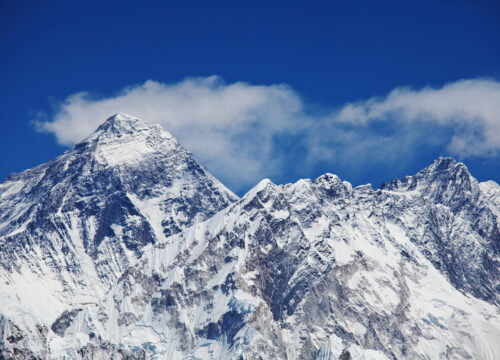
Early morning flight from Juphal to Nepalgunj. This fantastic 35-minute flight passes over the Himalayan foothills and offers stunning views of massive peaks to the north, such as Annapurna and Dhaulagiri. After that, you join the airplane headed back to Kathmandu. Hotel room for the night in Kathmandu.
Book Now
Trip Information
Max Guests
Min Age
Tour Location
Country
Price Includes
- Airport Pick up/drop
- Accommodation in kathmandu
- All inclusive trek such as Ground transportation, necessary permits ( including special permit), entrance fess, professional guide, porter/porters, and their expenses including their insurance and equipments
- Accommodation in the tent ( Mattress, sleeping bags) or at guest houses/home stays
- Three meals a day (breakfast, lunch & dinner) with cup of tea/coffee
- All domestic flights
Price Excludes
- Alcoholic drink
- Tips
- Your insurance
- Personal/natural expenses
- Food in Kathmandu